Prepare to be disappointed, Winter Lovers. For south Mississippi, it is just as I expected: Not as cold as others suggested.
Click-baiters strike again
Usually, this is when I harp on those “Super Storm Chasers Weather Alerts” facebook pages. But other – usually credible – meteorologists were posting about it a few days back! I’m not going to name names, but if you follow folks you trust on social media who were sharing the 10-day-away model data showing cold air spilling into the south, you should probably (virtually) shoulder-tap them today.
Color me salty, but I promise I’m not grouchy because it bothers me.
I’m grouchy because it gets others concerned (unnecessarily) given that we’ve all experienced an unusual winter. We’ve been cold – very cold! – at times. And warm at other times. We’ve had snow in places that rarely get snow. And severe weather just a few days later.
A lot of people are a bit more sensitive to extreme weather forecasts than they usually are. And that is completely understandable. Turns out, some meteorologists and weather enthusiasts may be, too.
But the problem is, when everyone sees someone posting a map with snow on it in a place that it doesn’t normally snow, people (rightfully) think, “Well, here we go again.”
Except, not really. Almost every model has eased back on how far south the cold gets to start February. And this ‘easing back’ is normal.
What happened? They said cold! And snow!
Now both the American model (GFS) and the European model (ECMWF) suggest temperatures south of I-20 in Louisiana, Mississippi Alabama and Florida to be around 30 overnight with highs in the 40s and 50s.
Check out the difference in the 500mb maps. The once deep-into-the-south-of-Texas trough has been relegated to trying to sneak across the Kentucky Tennessee border.
[slide-anything id=”28538″]
And if the 500mb maps don’t show a big trough cascading into the south, there won’t be much cold.
Like most model data that is more than 240-hours out, the original batch of data that got everyone concerned was a bit exaggerated. And people, likely looking for clicks, posted it with little hesitation.
Ain’t no such thing as half-way “arctic blasts”
Okay, so borrowing a line from Mobb Deep may be a little extreme. Could it still be cold? Sure. Could it be even colder than the current model data is showing? Absolutely.
Could the original forecast of snowfall for south Mississippi, south Alabama and – as someone put it – “flurries for Florida” still happen? I suppose. Though it is looking pretty unlikely.
But that isn’t my forecast. And has never been my forecast. I prefer to use ensemble data when looking out further than seven days. And then I tend to verify the forecast by comparing it against the CIPS Analogs.
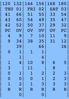
Above is the ECMWF model data showing that Saturday morning as the coldest day with the average temperature between the members of the model in the mid 30s.
Below average. Chilly. But not very arctic.
Additionally, the CIPS shows temperatures, between the February 1st and February 4th, as average. South Mississippi, Louisiana and Alabama are – generally – on the fence between above average and below average areas.

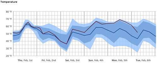
When you compare the above image to the way it looked a week ago when we were sitting in the teens in the morning, you start to get the idea that it may not be as cold as last time. Or even close.
I’m not shutting the door on cold air, completely. There is still a chance we get pretty chilly. But I think we will have to wait a bit longer to get it.
So what IS the forecast?
The forecast is still the same. After a chance for some showers and storms on Thursday, with highs in the 60s we turn cooler. Not arctic, just cooler. Friday and Saturday, across the region, lows will bottom out in the upper 20s and low 30s south of I-20. And afternoon highs will get into the 40s and 50s.
Below average. Chilly. Maybe even a bit cold overnight. But not arctic. And not blasting.
Just winter.


