Taking a look at the CIPS Analogs this morning, a trend of “slowly increasing storm risk” finally got to a breaking point, and it is time to pass along the threat: South Mississippi is looking at the threat for storms and severe weather three of the next six days.
What DOES this mean?
This DOES mean that storms are possible. Stay weather aware, the chance you hear thunder and see storms is higher than normal.
WHAT DOESN’T this mean?
This does NOT mean there will be massive amounts of crazy severe weather three of the next six days.
Here are the maps
WEDNESDAY:
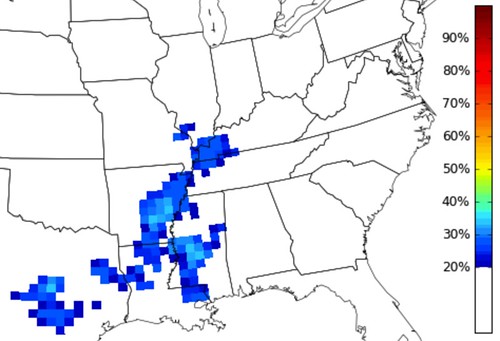
Wednesday and into Thursday morning the area will likely see some storms. The questions remains, just how severe will the storms be? As of this writing, most guidance tends to suggest an opportunity for some heavy rain, lightning, gusty wind, small hail as the main concerns. The tornado threat is pretty low, but not zero.
The CIPS Analogs Guidance is showing a 20- to 40-percent chance that, historically, a storm in this type of setup turns severe.
The parameters aren’t lined up at this time to support widespread severe weather, but an isolated strong or severe storm hidden within a line of regular storms is possible.
FRIDAY
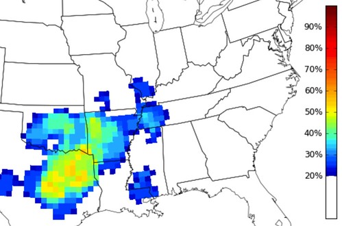
The threat for severe weather Friday will be very isolated. In fact, the area may be hard pressed to find a storm at all. But the background environment may be capable of sustaining a severe storm, if one can get developed. While the individual parameters are not sufficient based on model guidance data, it can’t be ruled out given past events.
The CIPS Analogs Guidance is showing a 20- to 30-percent chance that, historically, a storm in this type of setup turns severe.
I’m not as sold on Friday as Wednesday and (the next day I’m about to discuss) Saturday.
SATURDAY
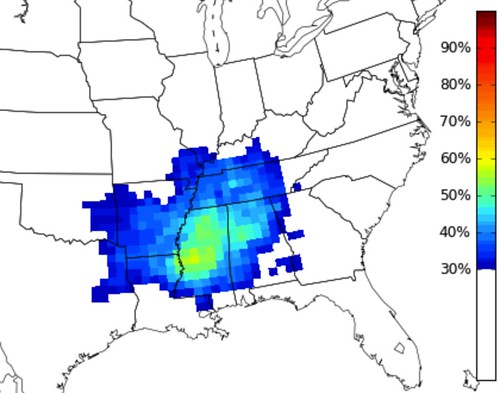
Saturday, the area will likely see some storms. The NOAA Storm Prediction Center already has a section of the area outlined for a 15-percent risk of severe weather. In general, that means – if nothing changes – we can expect to be under a “Slight Risk” for severe weather. The questions remains, just how severe will the storms be in our area? In central Mississippi, as of this writing, most guidance shows better support for severe weather. In south Mississippi, it isn’t quite as black-and-white. Numbers right now tend to suggest an opportunity for some heavy rain, lightning, gusty wind, small hail as the main concerns. The tornado threat is on the low ends, but certainly not zero.
The CIPS Analogs Guidance is showing a 20- to 50-percent chance that, historically, a storm in this type of setup turns severe.
The parameters aren’t lined up at this time to support widespread severe weather for south Mississippi, but a few isolated strong or severe storms ahead of the line of storms – or even hidden within a line – are possible.
Take home message
Keep an eye on the forecast this week. Please don’t be surprised by the weather, as it may bring the chance for strong or severe thunderstorms. More updates will be posted as more data becomes available.


