Early indications are suggesting that next Tuesday may be a stormy day for the Pine Belt. But there are still a lot of things that are “up in the air” so to speak.
But I anted to plow through some of these things to give you an early heads up, as well as, full context to the environmental set-up so you can fully understand what is going into the forecast for next week.
Because, like most weather in Mississippi, it’s a doozy!
The Setup
This isn’t looking like a setup for a severe weather outbreak. Nor is it even a particularly perfect setup for severe weather, even in general.
But there are a few indicators that have raised my eyebrow (But not Karrie’s yet) as far as the threat for a sever storm or two – or maybe more – for Monday and Tuesday.
Let’s look at the overall setup. At the surface, on Tuesday afternoon, a cold front at the surface looks to “lay down” as it slides south toward the Gulf of Mexico. That means it will take a orientation a little more west-to-east than north-to-south as it approaches the Gulf of Mexico.
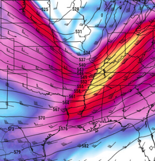
Looking at Tuesday afternoon, guidance from the GFS Computer Weather Model shows a decent trough ripping across parts of the central United States (pictured here). This may feature a decently strong Jet Streak (different than a jet stream) from northern Louisiana to southern Ohio.
In fact, looking up at 300mb, the Jet Streak is actually out of the trough by Tuesday afternoon leaving south Mississippi in the area of the “right entrance region” of the Jet.
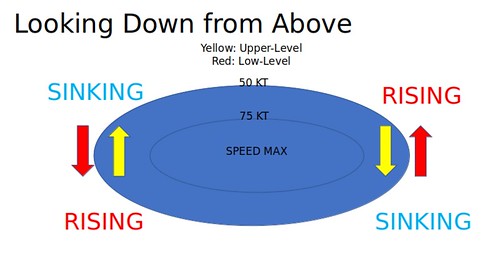
The right entrance region of a Jet Streak, as you can see above here, is a place where in the lower levels colder air is moving in from the north, and in the upper levels warm air is moving north from the south. It is not as conducive for producing severe weather. Because colder air is being pushed under warmer air. And that creates stability, not instability.
But that is Tuesday afternoon. Let’s look at early Tuesday morning.
On Tuesday morning, all of Mississippi is in the right exit region of the Jet Streak. And looking back at the diagram above, that puts Mississippi in an area where in the lower levels wind is moving from south to north, pulling in warm air from the Gulf of Mexico. And, at the same time, in the upper levels air is moving from north to south, pulling colder air down from Canada.
Well, golly! That is actually promoting instability because it is pushing warmer air underneath colder air!
And what do thunderstorms and severe weather need? Instability!
So let’s check the maps. Is there going to be any instability late Monday night and into Tuesday morning?
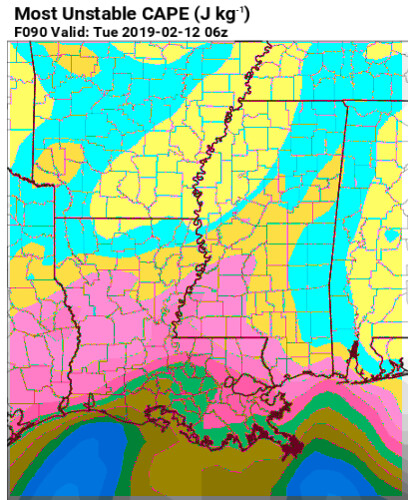
The colors on this map have been enhanced to highlight where there is a change in data ranges. The yellows and blues are values under 100. The browns and pinks are over 500. Looking at the data, though, nothing on here looks overly-impressive. instability values (known as CAPE) will be between 100 and 500, on a scale that can produce numbers as high as 8000.
Not exactly “high” by any stretch. But, then again, that map is likely going to change, and the current values are probably wrong.
I know, I know… then why show it? To highlight a problem.
/ENGAGE NERD ALERT!/
Instability maps like CAPE are often computer derived products that don’t always take general meteorological trends into account. I know that sounds counter-intuitive and ridiculous, but it is true.
So when I see our area in the right exit region of a Jet Streak, I tend to keep tabs on things a bit more – even if there is no instability shown on a map.
/CEASING NERD ALERT/
There are a few other things that the area has going for the chance for severe weather on Tuesday morning, too.
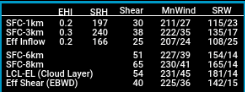
There will be plenty of shear in the atmosphere. Shear values will be up over 30 and helicity values will be greater than 100.
There will be a wide area of increased vertical motion ahead of the front. This will promote the development of, and sustain, updrafts. Coupled with increased shear, that means that storms that do develop will be able to maintain organization.
Much like the CAPE example above, these things do not guarantee severe weather, but it does mean that the potential exists.
The Analogs
Comparing what the models think this event might look like up in the atmosphere against what past events looked like int he atmosphere is a great way to lay a fence for expectations.
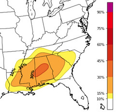
hat means, there looks to be a chance for severe weather across most of the state of Mississippi but a stripe with an even higher risk into parts of Alabama.
You can think of these percentages on the map a lot like the categorical risks from the Storm Prediction Center. A 10% is a “Marginal Risk” while a 15% is a “Slight Risk” for severe weather. Once the numbers get up over 30% it is an “Enhanced Risk” for severe weather.
But what about the Operational GFS? So glad you asked!
The Operational GFS-fed CIPS Analogs show a slightly different – but reasonably similar – threat for severe weather across the region.
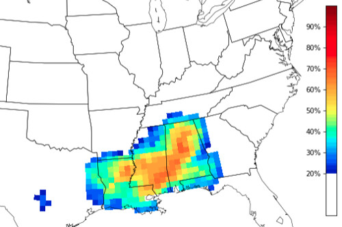
The main difference is that the Operational GFS-fed CIPS Analogs shows an increased likelihood that similar setups have produced severe weather in the past. In fact, a bulls-eye of 2/3rds of the time is over South Mississippi.
That means that, looking at the Top 15 times the atmosphere looked the way the models are suggesting, severe weather occurred two out of every three times.
That is, sadly, pretty good odds. And why I’m monitoring the threat for severe weather on Tuesday despite the lack of instability shown in the model data.
The Outcome
The specifics about the outcomes are still unknown, this is what we can know as of now.
1. it does look like the rain on Monday night and into Tuesday will feature some storms
2. There will be the potential for severe weather, but it isn’t a slam dunk.
3. The timeline for sever weather looks to be after 1am Tuesday morning but before noon.
4. Widespread flooding is looking less likely
5. The air that moves in after the rain won’t be very cold.
What still needs to be figured out
1. How far north the warm front makes it on Monday
2. the orientation of the cold front overnight Monday into Tuesday
3. Where the Jet Streak is during both of those events listed above
When will we know those things?
That’s tough to say. Sometimes with Jet Streaks you can get a better idea on placement – both geographically and temporally – by watching model trends. Meaning there wouldn’t be an exact time when we would know more than we know now.
We should get a better idea about the warm front’s movements by Sunday. As for the orientation of the cold front, we will get a better idea by Sunday, too. But we won’t *know* about it until Monday.
Bottom Line
Get out and enjoy your weekend! It will be a bit cooler Saturday and a bit cloudy Sunday.But in South Mississippi it won’t be a bad weekend to be outside.
And keep tabs on the weather during the next few days. Check back for updates, and know that there will be changes to this forecast. So please be prepared for that, too!


