(PINE BELT) – Showers will continue to be hit and miss through the evening. Rain should continue to be light. A few heavier showers have developed north of I-20 but those should stay out of the area.

If you are in a flooded area, away from streams, creeks and rivers the water shouldn’t rise much for you. The ground is already saturated, so any extra rain isn’t going to help, but it won’t hurt much, either. Given the rain will continue to be light, there shouldn’t be enough to add any appreciable depth to the water levels.
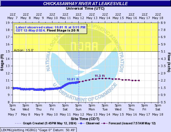
If you live in a flooded area near local streams, creeks and rivers, the water will continue to rise through -at least – tonight. Some of the area rivers have crested, while a few others will crest tonight. The rest of the area rivers will crest either Sunday, Monday or Tuesday.
You can find a list of local river gauges here: http://nickelblock.com/?page_id=27437
If you live in a once-flooded-but-now-dry area, the rainfall may cause some ponding in your yard. But it won’t likely be heavy enough for a long-enough period of time to cause widespread flooding.
A few questions we have received:
I live along a river, when will the waters recede near me?
That depends on your location. Please check the link above to see what the river levels are doing nearest your location.
How do I know what a river level means for how much water is at my door?
Every area is different. But, this link from FEMA may be helpful: https://msc.fema.gov/portal/search?AddressQuery=Hattiesburg%2C%20ms#searchresultsanchor
Also, this Flood Inundation Interactive Map may be useful from the USGS, too: https://wimcloud.usgs.gov/apps/FIM/FloodInundationMapper.html#app=dc6c&909f-selectedIndex=0&2a33-selectedIndex=0&1ac8-selectedIndex=0
There is no river gauge on my creek, how do I know how high it will get?
Sadly, this is a question I cannot answer. However, I would encourage you to ask neighbors and other community members who have lived inthe area for a while. They may have an idea about how high the creek or stream was during recent flooding events. From there, you can make an estimate.
There used to be a gauge on my river, but it isn’t listed anymore. Why is there no gauge or forecast on my stream, creek or river?
The USGS, United States Geological Survey, maintains the river gauges. During the last 30 years, due to funding cuts, many river gauges have not been replaced once non-operational. The LMRFC, Lower Mississippi River Forecast Center, monitors river levels using these gauges. If there is no longer a gauge, the LMRFC cannot issue a forecast for that point anymore.
I live in a valley, but not near a river, and there is still standing water. When will it go away?
That also depends on your location. The ground is very, very saturated right now. Given that there is rain in the forecast through Thursday, don’t expect the water to fully recede until next weekend.
I have damage and no one is helping me. What can I do?
Contact your local county emergency management officials. They will be able to allocate resources (though, it might not be immediate) to help you. They will also add your name and location to the list of damaged areas. This could help with insurance claims – if needed – at a later date.
The water has receded near me, and I have damage. How should I clean up? Make an insurance claim?
Head here first: https://www.floodsmart.gov/flood/document-damage-and-start-clean-up
And remember, regular insurance doesn’t cover flooding. That is why it is so important to have flood insurance.
It is still raining near me. Will this make the flooding worse?
The rain that is falling today isn’t bad enough to make the flooding worse. It will, however, slow down the receding waters a bit.

