A decent model shift tonight may make snow-lovers a bit happier. That said, I’m not completely sold, yet. Because forecasting wintry weather in the South is tough. The proximity to the Gulf of Mexico makes accurate temperature forecasts troublesome – for humans and computers. Having a big bowl of 70-degree water right next to a massive push of arctic air is a recipe for Mother Nature to humble meteorologists. And computers. That said, I think we did pretty well today, though. Yesterday we were thinking…
It is going to be pretty chilly Wednesday, Thursday and Friday. Afternoon highs will struggle to get past 45 in the afternoon. And depending on the rain, it may be cooler than that.
Today, Wednesday, the high was around 40 for most of the daylight hours. Off and on rain mixed with sleet, too.
I’m hoping to make it 2-for-2 tomorrow. But I’m not betting the farm. We have some new model data to chew on and it is showing more moisture and cooler air which could set us up for more snow… or more disappointment.
So, here is a look at what we know, what we don’t know and what we can’t know. As well as the forecast for right now at the end.
What we still know
1. It’s going to feel cold.
Afternoon highs during the next few days will be in the mid 40s in the afternoon. Overnight lows will be in the mid 30s Thursday morning, and near – but above – the freezing mark Friday morning. That means that a good chunk of the day will be below 40 degrees.
2. There will be precipitation
And cold air plus precipitation makes things more interesting. Especially when that cold air features temperatures around the freezing mark. I know what you’re thinking, snow lovers, and sadly it isn’t that simple. Just because it is around the freezing mark and there is moisture doesn’t mean we automatically get snow.
In order for snow to fall, you have to grow it first. You need to have a saturated Dendritic Growth Zone. That’s because most of the cloud droplets are still composed of liquid water – even when the temperature is below freezing. And there are also some water droplets (different than cloud droplets) that exist below freezing due to a lower air pressure, they are called “supercooled” droplets. In the subfreezing air of a cloud, many supercooled liquid droplets will surround each ice crystal that forms and freeze to it. But there aren’t as many as there are water droplets, so this process can take some time to create a LOT of ice and/or snow.
Here is the part that is different today. Look at the Skew-T model data for Friday morning that was rendered yesterday:

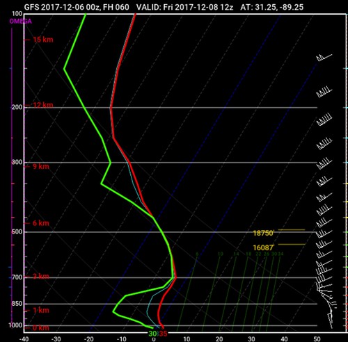
The red line and green line are close to each other above the 700mb line (10,000ft). That indicates that the atmosphere is saturated. And it is saturated in the Dendritic Growth Zone (DGZ). But, since the red and green line aren’t close to each other below – roughly – 10,000 feet, it means that any precipitation that may form higher up in the atmosphere, may evaporate/sublimate before reaching the surface.
Okay, so I know that might be a bit confusing, don’t forget, you can learn about Skew-Ts here.
Compare that Skew-T above to the Skew-T model data for Friday that was rendered tonight:

The difference? Well, take a close look. The red line and green line are close to / on top of each other from about 925mb up to about 400mb – a MUCH larger portion of the atmosphere. That change shifted the Dendritic Growth Zone (DGZ) a little higher in altitude. And expanded it by a few hundred feet.
Comparing the last four runs of the GFS model, take a look at the evolution of the Skew-Ts.
Going from upper left to bottom right, the sequence is:
Upper Left || Tuesday morning data
Upper Right || Tuesday night data
Lower Left || Wednesday morning data
Lower Right || Wednesday night data
Notice that the chart changes into more of an “S” shape? And that the gree and red lines get much closer together across more of the graph? That is showing that the model thinks that the atmosphere may be more moist in the lower levels, and therefore a little warmer. But still not above freezing.
What does that mean? It means precipitation – in whatever form it takes – is looking more likely.
3. Both above things will be true, simultaneously
Just like yesterday, I think it is a safe bet that someone, somewhere in Mississippi or Alabama will see wintry precipitation.
4. Weather models don’t handle snowfall estimates very well
Okay, I’ll be honest, they stink at it. Because it uses a long equation, any little ripple in the data can mean drastic changes. For example, the models use one equation to decipher how much snow will fall based on the ratio of 1 inch of rain is equal to 10 inches of snow. And if the atmosphere is below freezing from top to bottom, it assumes everything will be snow, and BAM, instant snowfall map.
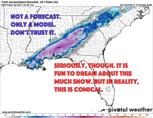
Remember this map from yesterday?

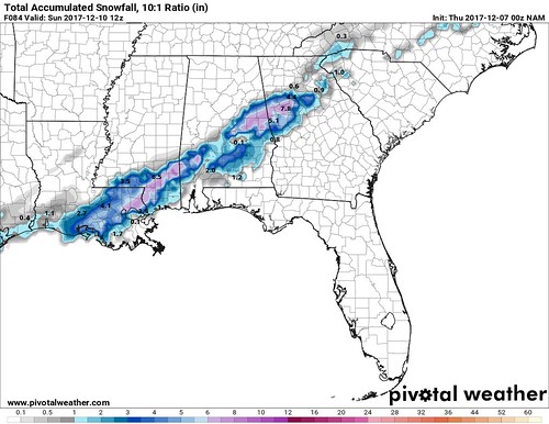
That same model shows this tonight:

These model data maps get shared a lot of social media, people take it as fact. But, an accurate forecast is not that easy. Things never are, right?
In this case, I tend to think every snowfall accumulation map is overblown for a few reasons…
1. The ground is still quite warm. It was like 80 two days ago.
2. The moisture may be there, but the forcing and vertical velocity will be lacking
3. Usually you need heavier precipitation rates along the Gulf Coast to get real snowfall going, and that isn’t looking likely
What we don’t know
1. How the secondary push of atmospheric energy will develop
This is probably – still – the biggest key to this whole mess. And we are starting to get a much better idea about how it will develop, but we still need another 12 to 18 hours to nail it down completely. But this is what the models are showing, right now:
The images above are for Thursday at noon. The ‘elbow’ in the trough looks similar is placement and dimension to what models were predicting last night. Perhaps a bit further west with a touch more energy. But again, this is something we won’t have nailed down for another 12 to 18 hours.
2. How hard the precipitation (whatever it is) will be falling
Getting snow to fall all the way to the surface along the Gulf Coast – generally – takes heavier precipitation than places further north. The reason? You have to overcome either (a) a warm layer between the snow high up in the cloud and the ground, (b) a dry layer between the snow high up in the cloud and the ground, or (c) a both warm and dry layer between the snow high up in the cloud and the ground.
If there isn’t much forcing in the atmosphere and the precipitation falls as drizzle or very light rain, we may not get snow to fall.
3. Specifically when, where and how much snow will happen
Weather prediction is tough. Snowfall prediction is tougher. Snowfall prediction in the south is even tougher. Snowfall prediction in the south three days out is even tougher, still. Snowfall prediction in the south, three days out, for specific places, towns and individual houses is impossible.
I wish I had a Magic Ball I could look into to find out this info, but is simply doesn’t exist. And anyone prognosticating that there will or won’t be snow in a certain place or at a specific time is full of it. Anyone that starts to put out accumulation estimates? Avoid them.
What we can’t know
Due to the distance between forecast points (we call that “resolution” in the weather world) on the forecast models, we can’t know if it will snow specifically at your house more than 12 hours out along the Gulf Coast. And even that is a stretch.
Just like with severe weather and hurricanes, the closer we get in time, the more and more we know about the forecast. We can offer more and more specifics the closer we get. But for now, we can’t know if you, specifically, will see snow.
The bottom line forecast
Thursday: Cloudy all day with passing showers and drizzle. The rain may mix with sleet at times, but it should remain mainly liquid. Highs around 45.
Friday Morning: Passing showers of rain, snow and sleet between 5am and 9am. Temperatures in the mid 30s. Meaningful accumulations not anticipated but it may accumulate on roof tops, grass and bushes and other exposed surfaces. Travel should not be affected.
Friday Afternoon: Precipitation ends, clouds remain. Still cold. Temperatures around 40.
In all, this will be a novelty snow. Fun to look at. It will make it feel like Christmas. But it shouldn’t affect life much beyond the ‘cool factor’ of having it for a few hours on Friday morning.

