Looking at the latest model data as well as the trends, it appears that the chance for showers, storms and some severe weather appears to be right on track with previous forecasts – with a slight shift.
The a deepening area of low pressure moves from SW Kansas and into SW Wisconsin, it will open the door for thunderstorms to develop from – roughly – southern Illinois, southern Indiana, southwestern Ohio, throughmost of Kentucky, western and central Tennessee, extreme southeastern Missouri, eastern Arkansas, all of Mississippi, eastern Louisiana and most of Alabama.
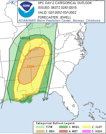
Because of this, the Storm Prediction Center out of Norman, Oklahoma has issued Day 2 products giving you the heads up that severe weather is possible.
The Marginal Risk (1/5) includes the largest area. A Slight Risk (2/5) still includes most of the area listed above. The Enhanced Risk (3/5) includes only central and western Kentucky, central and western Tennessee, Northern Mississippi and northwestern Alabama.
The main threats for any storm with this next system will be:
- Heavy rain & flash flooding
- Frequent lightning
- Hail (up to the size of eggs)
- Damaging winds (in excess of 70mph possible but not likely)
- Tornadoes (stronger or long-track tornadoes possible but not likely)
The setup
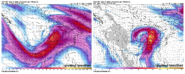
The 12z NAM shows the movement of the center of the system at 500mb (~18,000 feet) from SW to NE from Farmington, New Mexico on Monday afternoon to Omaha, Nebraska Tuesday afternoon. With the 500mb Low centered in Nebraska and the 850mb (~4,000 ft) almost stacked under it near Creston, Iowa, the differing flow around the two areas of lowest pressue will create a natural wind changing with height across a broad area southeast of the center.
The change of wind speed and direction as you move up in the atmosphere mixed with elevated CAPE (instability) levels will lead to the development of storms that will have the capability to become organized..
The term “organized storms” means that there will be one part of the storm where warm air is coming in, and the cold air is moving out. An organized storm often has a much easier time becoming a “severe” storm with winds in excess of 58mph with small hail.
But, let’s get back to instability. The difference in temperature between 850mb and 500mb will be important. At the lower levels (850mb) across the region outlined above, the winds will be coming in from the south off the Gulf of Mexico. At the same time, in the mid and upper levels (up at 500mb), wind from the west and northwest will also be coming into the region.
Temperatures at 15 degrees Celsius at 850mb will be sitting underneath temperatures at -15 degrees Celsius at 500mb. The roughly 30 degree difference between 850mb and 500mb will give the warm air at the surface an easier time to move up, cool, condense and form clouds. And, in fact, the difference between the two is called the Lapse Rate. steper lapse rates (higher numbers) mean more instability.
So, now there is a wide area where the warm moist air from the Gulf is unstable, and moving up in the atmosphere quickly. And, while it moves up in the atmosphere, the air is getting spun around from one direction to another.
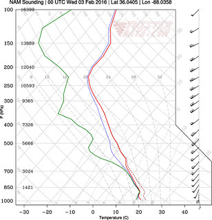
Take a look at the Skew-T chart on the left. While at 925mb (between 1000 and 850) the air is moving from south to north, at 500mb it is moving more from west-southwest to east-northeast.
And the wind speed is increasing from 40 knots to 90 knots.
The combination of the two is – generally – the beginnings of what forecasters look for when predicting the possibility of severe weather.
In this case, both are present.
The breakdown
According to the 12z NAM, this is how it looks on composite reflectivity.

It puts showers and storms across most of the region outlined by the SPC between Tuesday afternoon and Wednesday early morning.
The Timeline
I’m still working on this and will have it posted soon!


