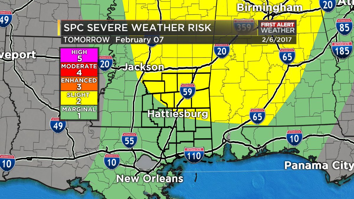
The Storm Prediction Center is having server issues, but has included parts of the Pine Belt and southern Mississippi in the Slight Risk for severe weather. Other sections have been added to the Marginal Risk, too.
That is a 2 our of 5 (Slight) and 1 out of 5 (Marginal) on their scale where 5 is the most severe.
This lines up with the Karrie Meter. The latest 12z Data suggested a 3.95 on that scale. Recall if you want to convert that back to the SPC scale, it is just divided in half. So the Karrie to SPC conversion leaves you with a 1.98.
1,98 is pretty close to 2. So when both the SPC and I come to the same conclusion, I tend to feel pretty good about the forecast.
It’s Never Easy
There is a problem, though. The problem is this isn’t a typical ‘cold front move through, storms develop, some severe, maybe a tornado, then we are on the backside’ kind of an event.
We are going to be using upper-level energy and diffluence as a means for storm development.
What does that mean? Take a peek!

To the right is a GIF of the 500mb Vorticity map from Pivotal Weather. At the end I run it back a few steps and then back forward again to highlight a particular area.
Notice that patch of red that starts in New Mexico and Texas that slides over the Louisiana and Mississippi. That is a bunch of ‘Vort Max’ at 500mb. It is what dictates how much energy (but not CAPE) storms have to work with in the atmosphere.
Often Vorticity is near the center of an area of low pressure. When we end up closer to it, often we have a better chance for rain / snow / storms / weather to happen.
I think Jeff Haby explains voriticty the best. Here is a brief snippet of his explanation:
Synoptic scale vorticity is analyzed and plotted on the 500-mb chart. Vorticity is a clockwise or counterclockwise spin in the troposphere. 500-mb vorticity is also termed vertical vorticity (the spin is in relation to a vertical axis). This vorticity is caused by troughs and ridges and other embedded waves or height centers (speed and directional wind changes in relation to a vertical axis). A wind flow through a vorticity gradient will produce regions of PVA (Positive Vorticity Advection) and NVA (Negative Vorticity Advection). PVA contributes to rising air.
Vorticity caused by a change in wind direction or wind speed with height is termed horizontal vorticity (the spin is in relation to a horizontal axis). Horizontal vorticity is most important in the PBL (low-levels of atmosphere). i.e. If the wind at the surface is southeast at 30 knots and the wind speed at 700 mb is west at 60 knots, there will be a large amount of speed and directional (veering) shear with height and therefore a large amount of horizontal vorticity.
For us, when we get wind changing speed and direction with height, it also means the chance for severe weather.
So here we are! Under an area of increased vorticity. That means bad weather, right? Nope.
It isn’t that easy. C’mon we all know that south Mississippi is never easy.
Often when we end up underneath a Vort Max, we also have a passing front, warm moist air at the surface, shear, helicity, CAPE values up, as well as a smattering of other severe weather parameters to add to the ‘fun’ of the forecast.
This time, we don’t have all of them where they need to be, at the right time, and in concert with each other. And it is also for that reason, that some of the quick-check parameters for this event may not be as applicable.
So, the forecast is tricky.
Notice that things look good for the development of severe weather in some places (Vorticity, Storm-Relative Helicity, and Mixed-Layer CAPE) but not great in others (Surface Dewpoint, SigTor, Updraft Helicity).
That is – mostly – why the SPC increased the Risk level. They are seeing some parameters inching up. They want to make sure you aren’t caught by surprise if a severe storm develops.
So we are going to have to play the wait and see game. But this is how I see it playing out…
Timing Time!
For Mississippi south of I-20, I think first storms move into Pike, Lincoln, and Copiah counties – as well as the Parishes of Louisiana – around 10am and enter Walthall, Lawrence and Simpson counties by 11am.
Then move across the area from West to East. Some may even have a WSW to ENE track.
Storms will reach the I-59 corridor by noon. Then exit into Alabama by 2pm.
This is only the first storms, I think we may see a few linger around through 5pm here and there. But the sever threat will be greatest with the first wave of storms around noon.


