
The SPC is continuing the Slight Risk for severe weather for sections of the Gulf Coast. As the next system swings through it will open the door for showers and storms to develop across the region. Some could be strong to severe, with wind gusts up to 60mph and the potential for a tornado or two.
I had a full discussion over on facebook Tuesday night. If you missed it, you can catch it here:
From the SPC
A somewhat complex scenario expected across the region today. Widespread cloudiness and showers will likely temper daytime heating, keeping temperatures in the upper 60s/low 70s. Modest low-level moisture is already in place but the anticipated mass response could contribute to a further increase. However, the strength of this potential moisture increase is predicated on the intensity/coverage of any upstream convection along the coast. Current expectation is for the bulk of the coastal convection to occur across southern AL/MS and the western FL Panhandle.
This leaves the potential for moisture advection across AL and MS, which could occur amidst backing surface winds and strengthening low to mid-level winds. Consequently, a corridor of slightly higher severe risk may materialize from far northeast LA across central MS into far west-central AL, near the track of surface low. However, even with this anticipated moisture advection, instability will be limited by poor lapse rates resulting from relatively warm mid-level temperatures. Instability is expected to be the limiting factor, given that vertical shear throughout the warm sector will be more than sufficient for storm organization/rotation. Uncertainty regarding instability as well as questions concerning the position of the front and any effects of antecedent precipitation preclude introducing higher severe probabilities with this outlook.
Current expectation is for thunderstorm coverage to begin increasing during the early afternoon, becoming widespread by 00Z Thursday. Damaging wind gusts within the bowing line segments along and just ahead of the front will be the primary severe risk. A few tornadoes are also possible, particularly within the corridor mentioned above where mesoscale ascent will augment large-scale forcing and surface winds will be more backed.
The Karrie Meter
It came back in the 3.5 range tonight. Originally, the Karrie Meter was designed for south Mississippi, but – with the help of Dr. Kim Wood at Mississippi State – I’m going to try to expend it a bit.
Tomorrow afternoon’s Karrie Meter (big thanks to @DrKimWood for the map) pic.twitter.com/LLaxUACeii
— Nick Lilja (@NickLilja) February 5, 2020
The map I tweeted earlier today is Dr. Wood’s handy work with Python. She managed to code up my Karrie Meter equation into a code that pulls out GFS computer model data and plots it all onto a map.
Here is a larger view:
Recall that the Karrie Meter is very touchy to increases in CAPE. So, it can indicate areas of concern where the concern isn’t as high if the CAPE values are higher.
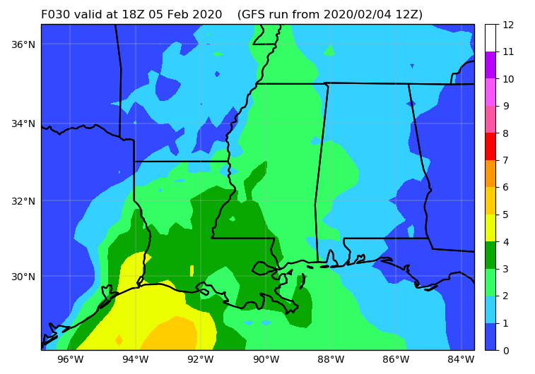
Here is a look at the CAPE values

That said, it would indicate that the greater risk for severe weather on Wednesday afternoon would be across parts of Louisiana and western Mississippi. Since the map above is just a snapshot in time, it is only able to make a prediction for the afternoon. Later in the afternoon and into the evening the threat shifts to the east and into parts of south and eastern Mississippi as well as southern Alabama.
Timeline
It looks like storms will move through the Gulf Coast region between 10am Wednesday and 7am Thursday. Specifically for southern Mississippi and southern Alabama, I think the local NWS offices have the timeline nailed pretty well.


For those in South Mississippi specifically, it looks like the severe threat will be between 3p and 11p. With a bulk of the threat for severe weather showing up between 7p and 10p.
What happened to The Blob?
Oh, The Blob is still out there.

Here is it circled in blue from the NAM computer weather model. There are other models that support a cluster of storms developing out in the Gulf, then passing near the mouth of the Mississippi, drifting to the east-northeast across coastal Alabama. If these storms develop, there is a chance they cut off the southerly flow into the inland areas of Louisiana, Mississippi and Alabama. That would help to lower the threat for severe weather across those inland areas.
It should be noted, though, that in the most reliable high-resolution model, the HRRR, The Blob isn’t picked up and it allows for a flood of warm moist air to push inland.
At the same time, though, the HRRR keeps most of the thunderstorm activity and severe weather close to the coast.
The inside scoop
I touched on this briefly during my live chat on facebook tonight that if The Blob materializes (and I think that is a prety likely scenario) there is going to be a shift in the severe weather threat from places like Alexandria, Columbia, Hattiesburg, and Thomasville to places south like New Orleans, Biloxi and Mobile plus to the north to places like Monroe, Jackson, Philadelphia and Tuscaloosa.
If that happens, the storms to the south along the coast would be mainly rain producers with the occasional tornado-warned storm because many will have the ability to get organized and rotate. Any tornado would likely be brief and weak.
On the flip side, the storms to the north would be instability starved (the SPC talked about this in their discussion above) but would have ample shear to work with, giving any storm – capable of sustaining any semblance of instability – a chance at turning severe and producing heavy rain, lightning, very gusty wind, hail and the potential for a tornado.
It looks like either way, the threat for large, long-track and devastating tornadoes will be rather low for tomorrow. Not zero, but low.
In the middle, there would still be the chance for storms. However, the threat would shift to mainly just regular thunderstorms with the outside chance that one can get rooted and turn severe. If that did happen, the hail threat may increase a bit givent he cooler drier air aloft as well as the lack of – as much – low-level moisture to fill the void of that cooler and drier air.
So, what’s the forecast? How bad will it be, really?
Well, the Storm Prediction Center has held on to the Slight Risk for severe weather across the region. That is a 2-out-of-5 on the 1-to-5 scale where 5 is the highest risk for significant severe weather.
The concerns are for heavy rain, frequent lightning, wind gusts up to 60mph, hail up to the size of quarters, and the potential for a tornado or two. All of this will occur between 10am on Wednesday and 7am on Thursday for the states of Louisiana, Mississippi and Alabama.
How bad will it be? That depends on your definition of “bad” I suppose. If “bad” to you is heavy rain and a lot of lightning, then, sure, for you it will be bad. If “bad” for you means an EF-5 tornado, then no, it won’t be bad for you.


