EDITOR’S NOTE: The SPC upgraded sections of the south to a Moderate Risk. Details here!
(Editor’s Note: I’m currently battling a fever and did this while taking cold medicine, please be understanding of typos)
As a deepening area of low pressure develops across parts of eastern Texas and moves across Arkansas, Mississippi, Alabama, and eventually into Georgia, the threat for severe weather will be present for Tuesday and Wednesday.
As is usually typical with this kind of scenario, there will be plenty of available shear – and in this case, according to model data, an abundance of it – with limited instability.
Currently, as of Sunday February 21, the main threat for severe weather will break down as follows:
Tuesday afternoon for eastern Texas, and Louisiana
Tuesday night for eastern Louisiana, extreme southern Arkansas, and western Mississippi (south of the I-20 corridor)
Tuesday overnight into early Wednesday morning for eastern Mississippi (no limitations on north-south line), western and central Alabama <– For more info about this forecast click here
Wednesday afternoon for eastern Alabama and Georgia
The Setup
As mentioned above, a deepening area of low pressure will develop in East Texas. In early runs of most models, this feature wasn’t quite as stout as it has been shown in the last 18-24 hours. The overall strength and position of the Low will have a tremendous impact on the severity and placement of the severe weather on Tuesday and Wednesday.
A weaker Low would prolong the rain and thunderstorms but would ease the overall threat for severe weather. A stronger Low could increase the threat for severe weather, but it would also mean a faster moving system, so the overall threat would be quicker to develop and leave across all areas.
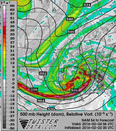
I think the most interesting thing to note is how the 18z and 00z NAM model showed the Low becoming nearly vertically stacked in Arkansas. When defining individual threats for this next system, If this stacking were to verify, the winds through the column of air would all be pointing the same direction. In turn, it could mean the threat for straight-line winds would increase while the threat for tornadoes could decrease – although, it wouldn’t decrease to zero. In fact, it would still be no where near zero. But, every little bit counts, right?
As the storm pushes across the Gulf Coast states, the atmospheric parameters present will be sufficient for the development of severe weather.
A cold front will push across the area sparking a line of showers and storms, as well as individual supercells out ahead of the main line.
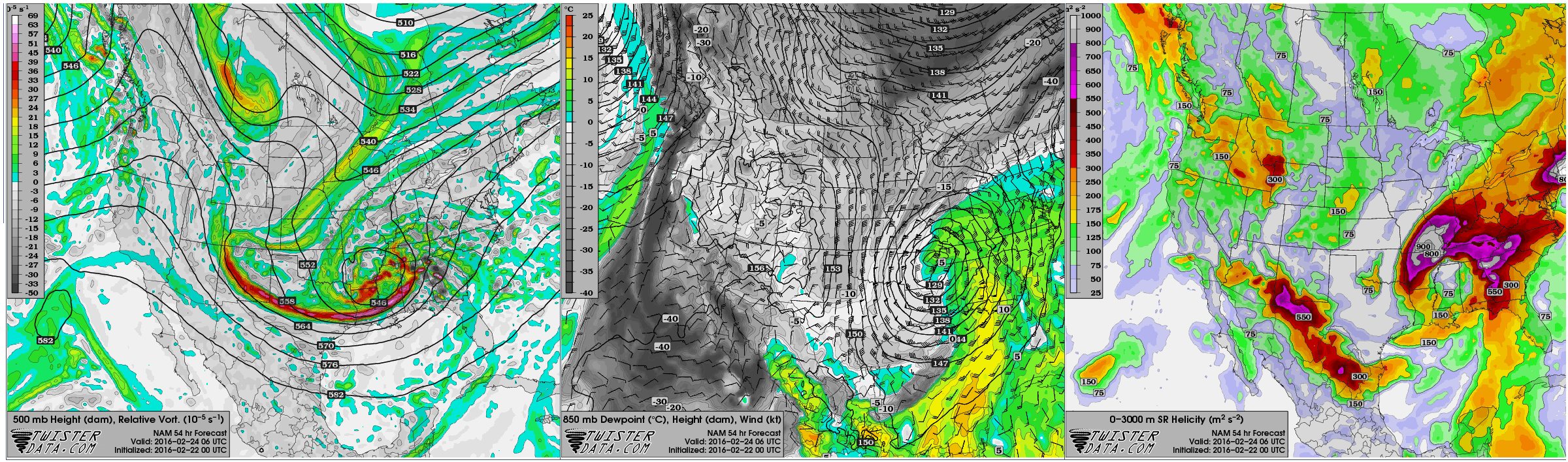
According to the 0z NAM model, instability values for the region will be between 500 J/Kg and 2,000 J/Kg. Bulk Shear values will be between 30kts and 70kts. And Storm Relative Helicity values will be above 100 in all areas, with some places topping 500.
Often any run of the NAM is a bit overblown, but this lines up with the 18z GFS and is only slightly higher than the 15z SREF. It gives greater confidence to it’ validity. Though, admittedly, not complete confidence.
As of Sunday night (Reading this at a later point? For the latest forecast areas, click here!), the Storm Prediction Center in Norman, Oklahoma pegged an area from roughly Houston, Texas east through Lake Charles, Louisiana and Jackson, Mississippi down through Dothan, Alabama under a Slight risk for severe weather.
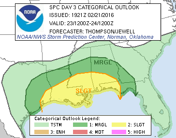
As a reminder, that is a two out of five, where five is the highest threat for severe weather.
The Marginal Risk – or one out of five on the same scale – stretches from the half-way-point between Corpus Christi and Houston, Texas to Shreveport, Louisiana and east toward Birmingham, Alabama and back southeast toward Tallahassee, Florida.
In the coming days, this area will likely be massaged as meteorologists continue to get a better grasp on the forecast. Based on model trends, it wouldn’t surprise me if an area between roughly Lake Charles, Louisiana Jackson, Mississippi and Mobile, Alabama ended up being slated with an Enhanced Risk – or a three out of five on the same scale – for severe weather.
The Breakdown
– Across eastern Texas and Western Louisiana on Tuesday afternoon, CAPE values will be into the 800-1200 range. according to the 0z NAM. That same model shows Surface-to-6000m Shear values between 30 and 50, Surface-to-3000m Storm Relative Helicity values above 600, and a SigTor between 1 and 2 near the coast.
Historically speaking, the CAPE and Shear values line up with tornadic development, but the Helicity and SigTor are too high.
– For southern Mississippi during Tuesday night and early Wednesday morning CAPE values will be between 800 and 1400 according to the 18z GFS, 18z NAM, 15z SREF and 18z WRF. On those same models, 6km Bulk Shear will be between 40 and 70, Helicity between 400 and 500 (the NAM and WRF both suggested values of more than 850, so omitting those results), and because of that, SigTor values are rendered meaningless. Though, they are shown to be between 2.5 and 5.5.
Historically speaking, this lines up with tornadic events in the past across the board. In fact, the Karrie Stress-O-Meter Index shows a 4.08 on a scale of 1 to 10. With 10 being the April 27 outbreak parameters.
– For Alabama on Wednesday morning and into the afternoon CAPE values will be between 800 and 1400 according to the 18z GFS, 18z NAM, 15z SREF and 18z WRF. On those same models and 6km Bulk Shear will be between 40 and 70. The Helicity are showing between 400 and 500 (the NAM and WRF both suggested values of more than 850, again, so omitting those results), and because of that, the SigTor values are, again, rendered meaningless. Though, they are shown to be between 1.5 and 6.5.
Historically speaking, things line up all across the board for the development of severe weather.
Using CIPS
The CIPS Analog Guidance from Saint Louis University is a great tool for determining if similar situations produced severe weather. Here is a look at the top 15 most analogous events:
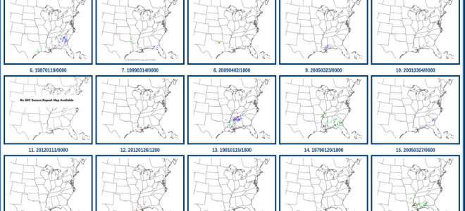
Notice that it is – sort of – hit or miss. Individual threats look like this:
The CIPS Analogs show that a similar situation produced a severe weather report 60-percent of the time. So, the threat for at least one severe report is decent.
The Bottom Line
Be prepared for severe weather anywhere across the south between Tuesday afternoon and Thursday morning. The main concerns are for heavy rain, frequent lightning, hail, wind in excess of 60mph, and tornadoes. This breakdown doesn’t include the threat for flooding which is a possibility, too. I will try to post an updated forecast as new data is available.


